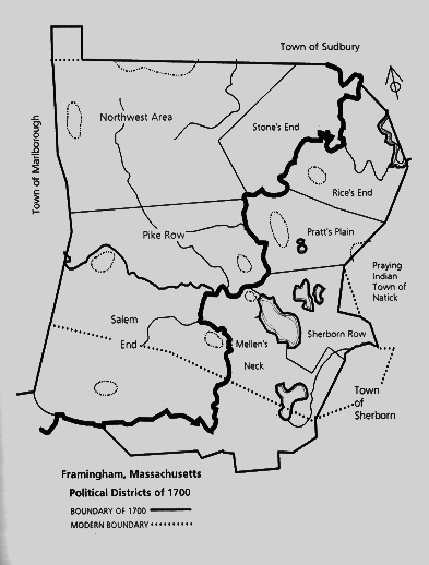
Framingham 1700 land designation. Thanks to "Framingham, An American Town" by Stephen Herring.
The Northwest Area, Pike Row and Salem End were part of the Danforth Farms, owned by Thomas Danforth. He had gotten an initial land grant in the 1660's that he kept adding to. In 1686, his vast land was up for grabs. Lessees would have to pay a stipend to Danforth and his heirs for 999 years in exchange for some land. Because Thomas Danforth was kind of a busy man, in 1693, he lent his land to Joseph Buckminster (a man with few principles) who in turn was supposed to sub-lend the land to whoever was interested.
Prior to 1700, most of Sherborn Row, Pratt's Plain and a piece of Rice's end (around Juniper Hill, just west of John Bent's land on the 1662 map below) were part of the Praying Indian Town of Natick, an Indian community led by John Eliot, a missionary minister.
Pike Row: Leased out to Jeremiah Pike, Abraham Belknap and others. Initially, it was just a tiny trail of about a mile connecting the houses of Jeremiah Pike and his son. Jeremiah Pike's house still stands today on Belknap Road.
Salem End: That's where the Salem refugees lived, in particular, Sarah and Peter Clayes (Cloyce in Salem), Benjamin Nurse and Caleb Bridges (all related to Sarah). Thomas Danforth was said to have helped Sarah and her family escape from persecution in Salem and establish themselves in what would be referred as Salem End.
Mellen's Neck: This land used to belong to Richard Wayte, Richard Russell and Col. William Crowne (granted in the 1660s, see 1662 map below). Danforth bought out Wayte's and Russell's land parcels before 1684 (maybe as early as 1669). In 1687, Simon Mellen and his son Thomas became two of the first Danforth Fams' tenants. The area became known as Mellen's Neck.
Sherborn Row: In 1662, it was mostly Natick land. The Eastern-most part belonged to the Rice family (see 1662 map below). Thomas Eames who probably was the first farmer to occupy land on Danforth Farms (Mount Wayte area) got a hold of the Natick part in 1677. He thought that this Natick land was actually his, considering what King Philip's men (King Philip was the anglicized name of Indian Chief Metacom) did to his family in 1676 (Eames Massacre). Eames kept a good piece of that newly acquired land for his homestead and sold off the rest to the Pratt family and Isaac Learned (of Learned Pond fame). The bit of land that belonged to the Rice family was bought off by Thomas Gleason (of Gleason Pond fame). The inhabitants of Sherborn Row were invoved with the Town of Sherborn, hence the name Sherborn Row.
Pratt's Plain: This Natick land was bought off by Samuel Gookin and Samuel How for next to nothing. The land was sold to the Pratt family and it became known as Pratt's Plain.
Rice's End: Henry Rice got land from his father Edmund, sold some of it to John Bent in 1662 (his original house was moved to Concord Street in 1745 where it still stands today). Thomas Drury, who married Henry Rice's daughter in 1688, bought land from Gookin and How next to the Rice farm and the land that was referred to as Appleton Farm (north of Cochituate Brook, see 1662 map below). The whole area was referred to as Rice's End.
Stone's End: John Stone's property. He erected a gristmill near The Falls in 1656. Stone's End would later become Saxonville.
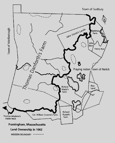
Framingham 1662 land ownership. Thanks to "Framingham, An American Town" by Stephen Herring.
No comments:
Post a Comment